

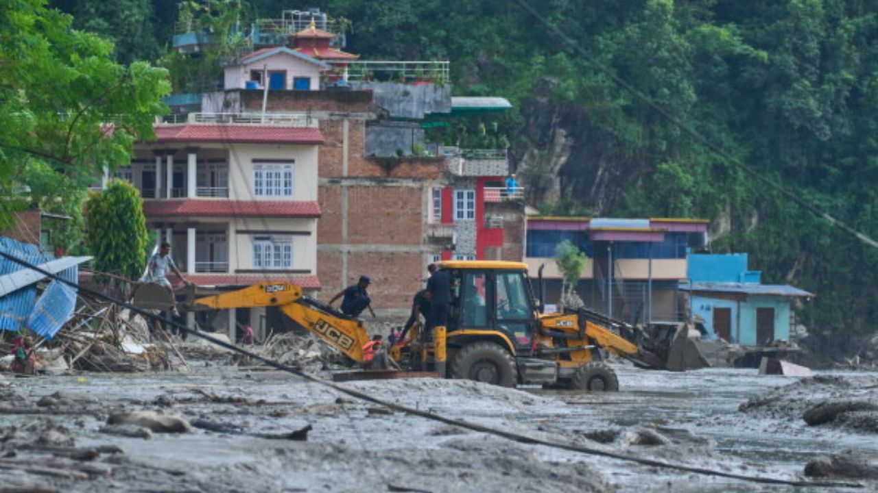



The devastating flash flood that struck Nepal on Wednesday was not simply an extreme weather event. It occurred at the intersection of several hazards that make the Himalayan nation one of the world’s most disaster-prone countries: rapidly changing glaciers, unstable glacial lakes, landslides, earthquakes and development along vulnerable river valleys.
About 9am on Wednesday, a wall of water swept down the Bhote Koshi River in Rasuwa district, destroying settlements near Nepal’s border with Tibet, China, before moving downstream into the Trishuli River.
More than 150 people were reported dead in Nepal by the evening, while around 400 remained missing, reports NDTV.
By Thursday, Nepalese police had reported at least 162 deaths, while hundreds remained missing. China reported three deaths and hundreds missing in Tibet’s Gyirong County. AP reported that 403 people were missing in Nepal, including 341 foreign nationals.
The disaster reflects two long-term processes. The first is the warming of the Himalayas, which is causing more water to accumulate in increasingly unstable locations. The second is the region’s active geology: Nepal lies along the collision zone of two tectonic plates, meaning the mountains themselves remain geologically active.
What triggered the sudden surge?
There are three preliminary accounts of what happened, but they broadly point towards the same chain of events.
Nepal’s Foreign Minister Shishir Khanal told the House of Representatives that an earthquake at 8:37am local time triggered a major landslide. The landslide blocked the river, he said, and the blockage later gave way, releasing a large volume of water.
The US Geological Survey initially recorded a magnitude 4.4 earthquake at around that time, approximately 47 kilometres north of Gosainkunda in neighbouring Tibet. It later clarified that the recorded tremors were not caused by an earthquake but by a landslide.
Scientists have offered a similar explanation, with some differences over the precise trigger. Saswata Sanyal of the International Centre for Integrated Mountain Development (ICIMOD) told CNN that the worst flooding occurred along the Lhende Khola, a tributary of the Bhote Koshi.

An ice-and-rock avalanche from a glacier may have blocked the river before the obstruction failed and released a sudden surge.
Rijan Bhakta Kayastha, a glaciologist and head of the Department of Environmental Science at Kathmandu University, also gave a similar preliminary assessment based on discussions with scientists in Nepal and China.
He noted that the Lhende Khola had been blocked during a similar incident the previous year. Satellite images from 24 August are being examined for evidence of water movement in the glacial area upstream, while before-and-after assessments have shown a sudden surge of water.
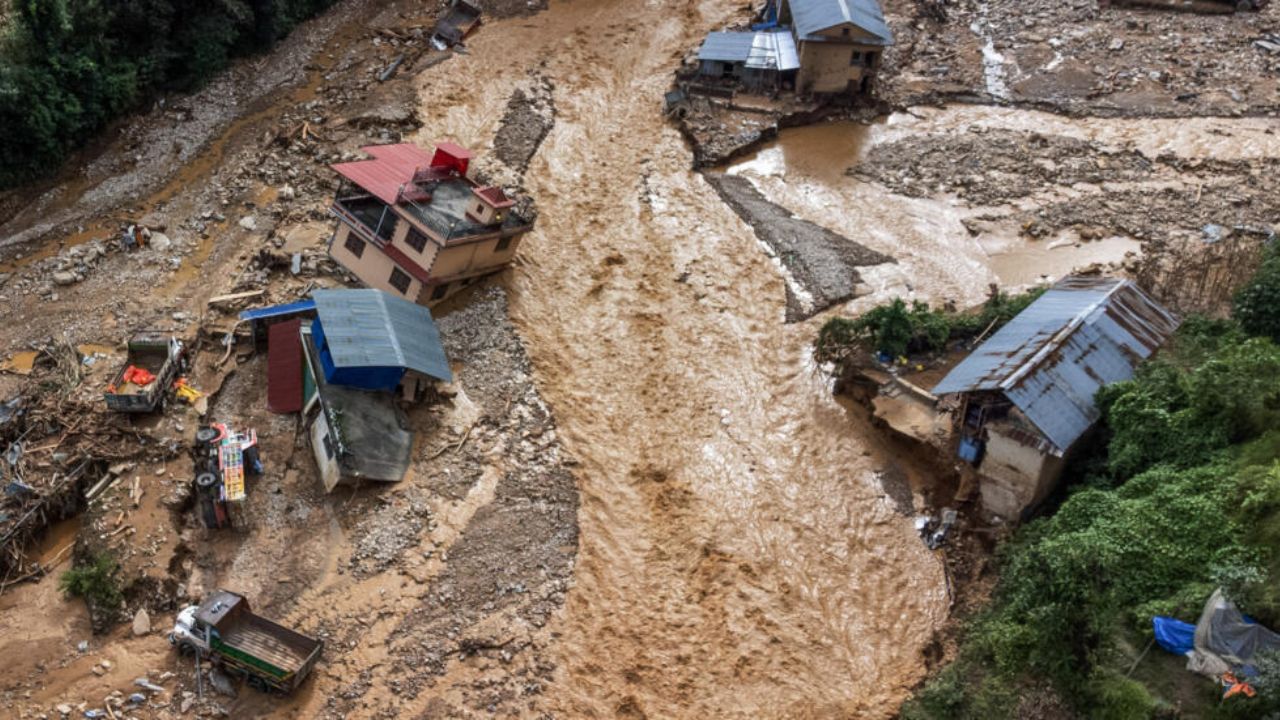
AFP reported that the extent of destruction caused by the muddy floodwaters, which damaged settlements and infrastructure along the river corridor. Images distributed by AFP showed houses partially submerged in mud and residents navigating streets covered with debris.
A centuries-old danger intensified by a warming Himalaya
Nepal is especially vulnerable to glacial lake outburst floods, sometimes described as “inland tsunamis”. ICIMOD recently reported that the rate of ice loss from glaciers across the Hindu Kush Himalaya has doubled since 2000. This increases the risk for the roughly 2 million people living downstream of glaciers and the rivers they feed.




The danger is not new. A similar flood in the same region last year was traced to a glacial lakeburst in upstream Tibet. In July 1981, a lake in the Zhangzangbo valley in Tibet drained suddenly without warning.
A later World Bank review said the cause was initially unknown and became clear only years later through a Chinese scientific report.
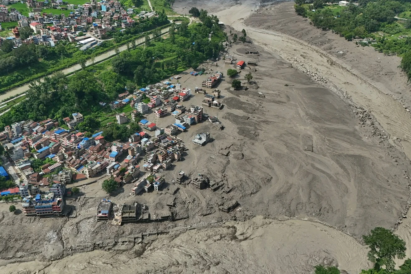
Research published in Nature and Scientific Reports found that the 1981 event, which killed more than 200 people, destroyed the Friendship Bridge and severely affected the Sun Koshi hydropower station. Major floods in 1964 and 1983 can also be traced to the same lake system in Tibet.
Nepal’s history contains an even longer record of such disasters. The World Bank has counted 24 major outburst floods in the country’s history, with 14 originating inside Nepal and 10 in Tibet.
One occurred about 450 years ago in the Seti Khola river system after a moraine holding back a glacial lake called Machhapuchchhre collapsed. The resulting flood caused widespread destruction in the Pokhara valley and left debris 50-60 metres deep in some areas.
A moraine collapse occurs when the natural ridge holding back a glacial lake fails, releasing the stored water in a sudden and destructive surge.
The 8 July 2025 flood at the Tibet-Nepal border has also been linked more precisely to a glacial lake. An analysis by the Washington-based Stimson Center attributed it to the sudden drainage of a supraglacial lake that had formed around 35 kilometres upstream of the border at an elevation of roughly 5,150 metres. Supraglacial lakes are pools of water that form on the surface of melting glaciers.
Hundreds of lakes, limited warnings and growing exposure
The scale of the potential threat is enormous. An inventory by the United Nations Development Programme in 2020 identified 3,624 glacial lakes across Nepal’s Koshi, Gandaki and Karnali river basins. Of these, 47 were classified as potentially dangerous: 25 in Tibet, 21 in Nepal and one in India.
Yet inventories cannot provide a permanent solution. Supraglacial lakes can appear, expand and drain within only a few seasons. As a result, a lake can emerge after an inventory has already been completed. The lake blamed for the 2025 disaster, for example, had previously gone unnoticed.
The lack of real-time information across the Nepal-Tibet border adds another layer of risk. After the July 2025 disaster, the director general of Nepal’s Department of Hydrology and Meteorology said there was no mechanism for Nepal to obtain data from the Tibetan region.
China does provide warnings about rainfall, but glacial lake outburst floods do not necessarily depend on rain.
Nepali officials said they were informed about an hour before the 2025 flood entered Nepal, and the information came from border security personnel rather than a forecasting agency.
Following that disaster, Nepal’s federal government decided to work with China on early warning and preparedness. In July 2025, the UN Green Climate Fund approved a grant of around $36 million to help Nepal address the growing threat. However, the latest disaster showed that there is still no real-time cross-border alert system.
The country’s geological setting compounds the danger. Nepal sits on the collision zone of the Indian and Eurasian plates, which converge at around 20-21 millimetres a year.
The Himalayas began forming about 50 million years ago when the plates collided and closed the ancient Tethys Ocean. The resulting folding and thrusting of the Earth’s crust created the world’s highest mountains.
That collision has never stopped. The Himalayas remain one of the youngest and fastest-growing mountain ranges on Earth, rising by roughly 5 millimetres a year. The immense strain generated by this movement is released through earthquakes.
For flood risk, even relatively small tremors can destabilise slopes already weakened by major seismic events such as the 2015 earthquake. In Wednesday’s disaster, shaking associated with a landslide, rather than an earthquake itself, was reportedly enough to destabilise a slope, block a river and contribute to the sudden release of water.
The final vulnerability comes from development. Construction along the China-Nepal trade corridors has not always accounted for the risk of glacial outburst floods. Research published in 2024 found that dry ports and customs facilities had been built along river plains exposed to such hazards.
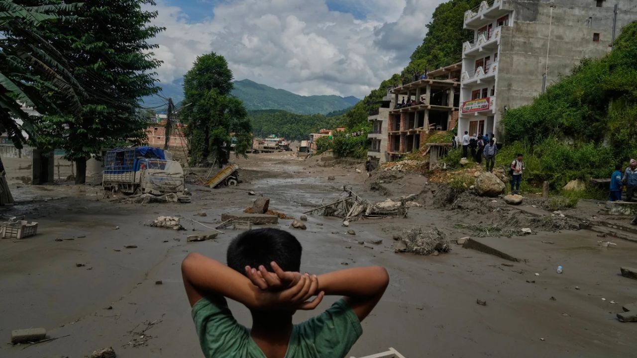
Research involving Nitesh Khadka of the Institute of Mountain Hazards and Environment, Chinese Academy of Sciences, Chengdu, estimated that GLOFs could have cross-border effects on about 103 kilometres of the China-Nepal highway, 103 bridges, two major dry ports and 3,301 buildings in the two countries.
The customs post at Timure, near the Rasuwagadhi crossing on the Nepal-Tibet border, has already been destroyed twice in about 13 months. Scores of tourists, including Indian pilgrims travelling for the Kailash Yatra, were among those who died in Wednesday’s disaster.
AP reported that 133 of the missing people were Indian pilgrims travelling to Mount Kailash, while others included nationals from the United States, Australia, Britain and Canada. At least 28 Nepalese police officers were also reported missing.
Nepal’s hydropower infrastructure is also exposed because the country depends heavily on fast-flowing mountain rivers running through narrow valleys and gorges. Wednesday’s disaster cost the national grid 430 megawatts of electricity, more than a tenth of the country’s total capacity.
And the danger does not end at Nepal’s borders. GLOF surges can enter the Trishuli, which becomes the Narayani at Devghat before flowing into India as the Gandak. An unmonitored glacial lake in Tibet can therefore trigger a chain of destruction stretching from the high Himalayas into Nepal and eventually towards the plains of Bihar.