


A steady warming of the Pacific Ocean is raising global concern, as scientists warn that a strong El Niño could emerge in 2026 and possibly intensify into a rare “super” event.
The first signs are not felt on land. They begin far away, across the vast Pacific, where the ocean quietly stores heat like a sealed furnace. Now, that furnace is stirring again.
Scientists across the world are watching closely as temperatures rise beneath the surface, hinting at a shift that has the power to redraw weather patterns from California to South Asia.
It is not yet certain, but the signals are strong enough to raise concern. A possible super El Niño may be forming, and if it does, its reach will not stop at coastlines. For countries like Bangladesh, where life depends on the rhythm of rain and heat, the consequences could be immediate and profound.
What is a super El Niño
El Niño itself is not new. It is a natural climate pattern that occurs when waters in the central and eastern Pacific Ocean become warmer than usual. This warming disrupts atmospheric circulation and shifts weather patterns across the globe.
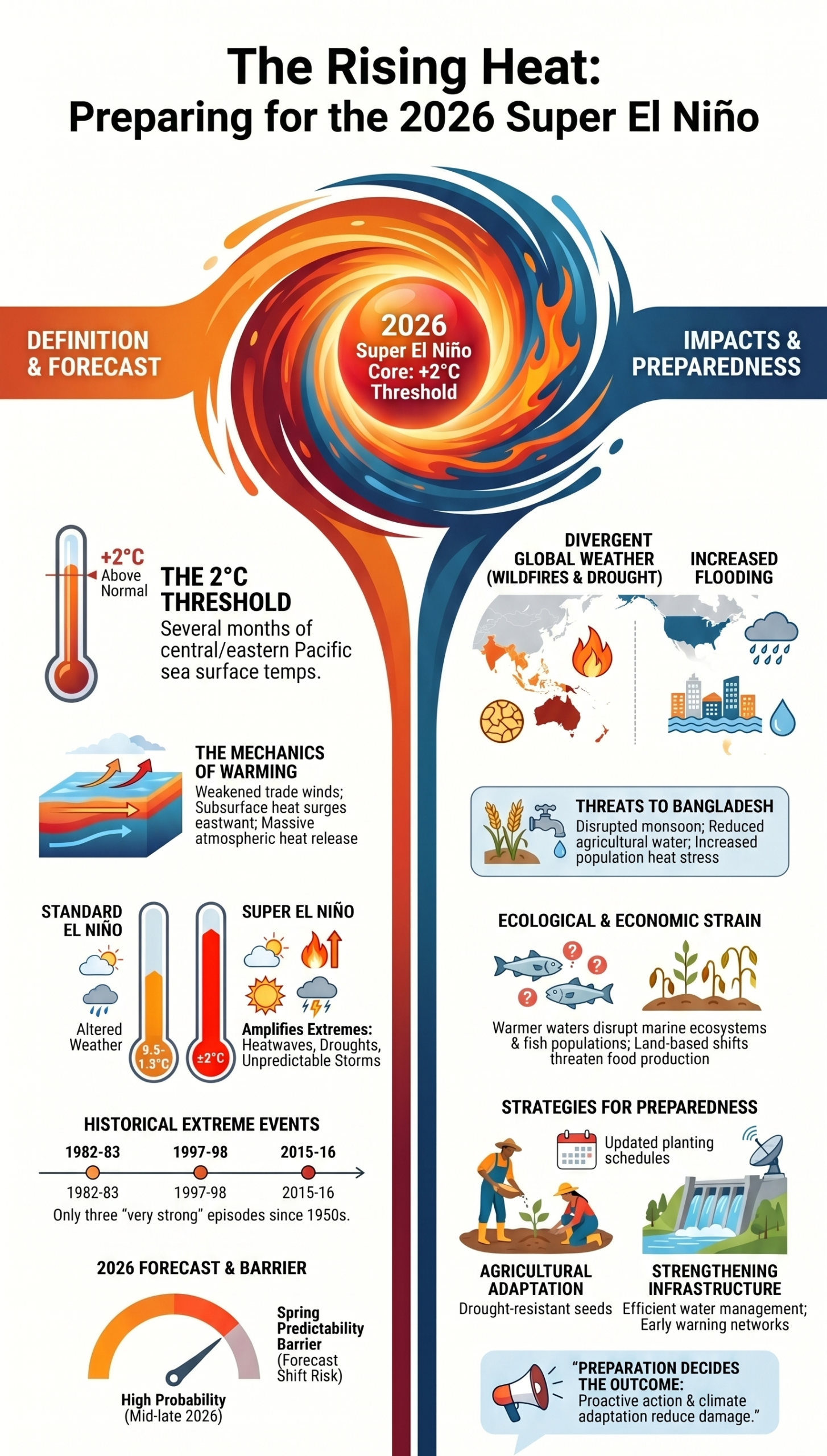
A super El Niño is simply a far stronger version of this event. Scientists classify it when sea surface temperatures rise at least 2°C above normal and stay there for months. Such events are rare, but when they occur, they tend to amplify everything — heat becomes more intense, rainfall more uneven, and climate extremes more widespread.
Other types of El Niño
Not every El Niño reaches extreme levels. Most events remain weak or moderate, with temperature increases between 0.5°C and 1.5°C. Some grow stronger but still fall short of the “super” threshold.
These variations explain why each event behaves differently. Even within the same category, no two El Niño cycles unfold in exactly the same way. That unpredictability is what makes early warnings both vital and uncertain.

Difference between El Niño and super El Niño
The distinction lies in intensity and impact. A standard El Niño alters weather patterns, but a super El Niño magnifies those changes. Rainfall can become excessive in some regions while disappearing in others.
Heatwaves intensify, droughts deepen, and storms grow more unpredictable. In simple terms, a super El Niño does not just shift the climate — it pushes it to extremes.
Why experts think it may be coming in 2026
The concern around 2026 is not based on a single signal but a combination of them. Climate models from multiple forecasting centres point to a warming Pacific Ocean.
Subsurface heat has already built up following recent La Niña conditions, a climate pattern marked by cooler-than-average sea surface temperatures, and powerful wind patterns are pushing that heat eastward.
Forecasts suggest a strong likelihood that El Niño will develop between mid-year and late summer. There is also a smaller but significant chance that it could intensify further.
At the same time, scientists warn of the “spring predictability barrier”, a period when forecasts often shift. This means confidence is high but not absolute. The event is not a certainty, but the probability is strong enough for governments and experts to prepare.
A look back: history of extreme El Niño events
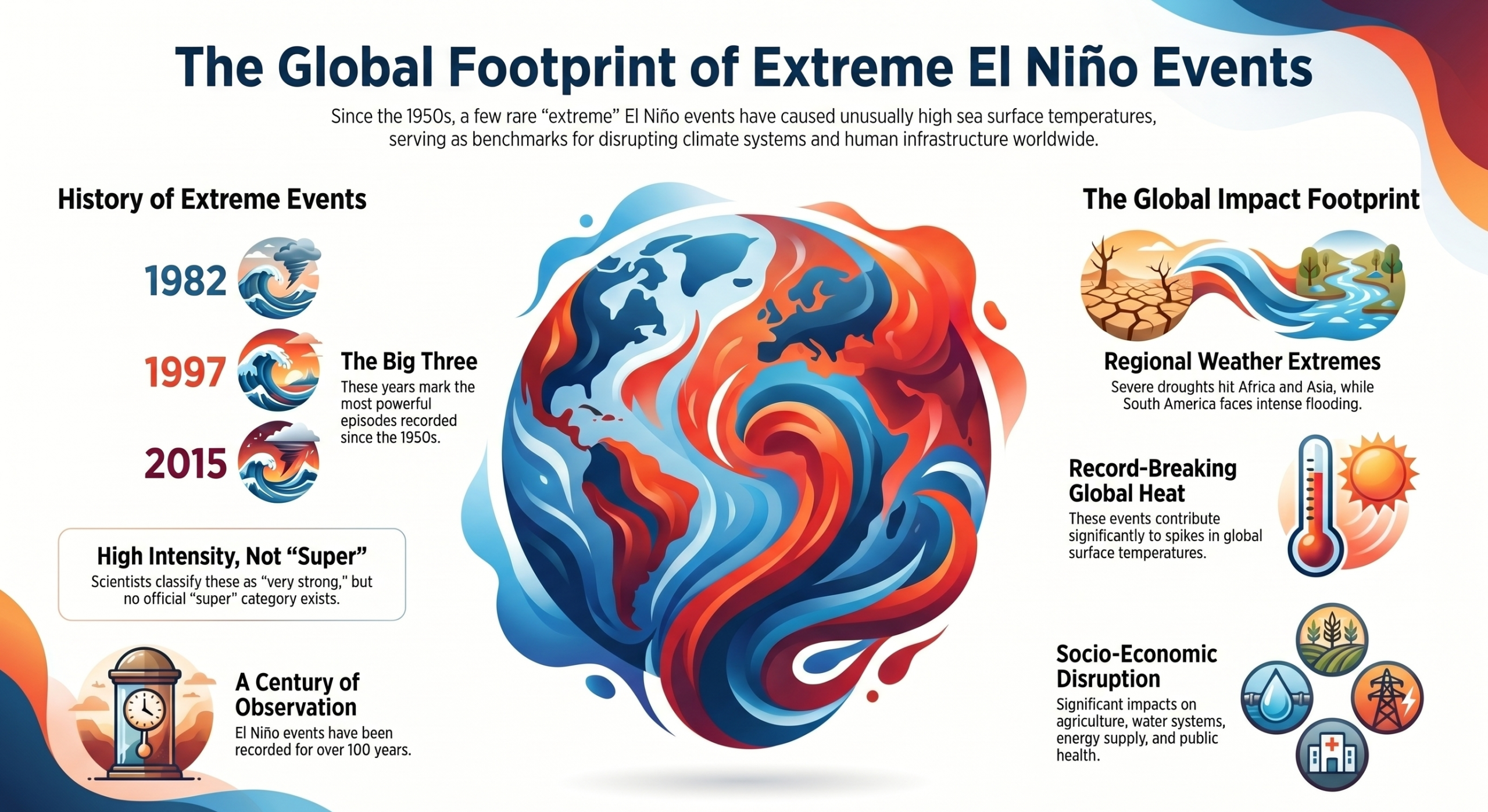
El Niño events have been recorded for more than a century, but only a few have reached extreme strength. Since the 1950s, scientists have identified several powerful episodes, most notably in 1982–83, 1997–98, and 2015–16. These events are often described in research and media discussions as very strong El Niño episodes due to their unusually high sea surface temperatures and widespread global disruption.




Each of these extreme events left a clear global footprint. They triggered severe drought in parts of Africa and Asia, brought intense rainfall and flooding to South America, and contributed to record-breaking global temperatures. Their impacts extended well beyond weather alone, affecting agriculture, water systems, energy supply, and public health across multiple continents.
Scientists often refer back to these events when assessing future risk, because they show how a single phase of ocean warming can influence climate systems worldwide when it reaches extreme intensity.
There is no confirmed scientific evidence or official classification of a distinct “super El Niño” occurring yet.
Why it happens
Under normal conditions, strong winds called trade winds blow across the Pacific Ocean from east to west. These winds push warm surface water towards countries like Indonesia and Australia, while cooler water rises near the coast of South America. This keeps the ocean temperatures relatively balanced.
During an El Niño, these trade winds become weaker than usual, or sometimes even reverse direction. When that happens, the warm water that was piled up in the western Pacific starts to move back towards the central and eastern Pacific. This spreads unusual warmth across a much larger area of the ocean.
In a very strong or “super” El Niño, this movement becomes more intense. A large amount of stored ocean heat rises to the surface and escapes into the atmosphere. This sudden release of heat disturbs normal wind patterns high above the Earth, including the jet streams that guide weather systems around the world. As a result, rainfall, storms and temperature patterns shift far beyond the Pacific.
Scientists also believe that long-term climate change may be making these events more powerful. As the planet warms, the ocean holds more heat, which can add extra energy to El Niño conditions when they develop.
Where it is forming in 2026
In 2026, the warming is concentrated in the central and eastern equatorial Pacific Ocean, which acts as the main driver of global climate shifts. This region influences jet streams and weather systems far beyond the Pacific, including monsoon patterns in South Asia. The behaviour of this area over the coming months will determine how strong the event becomes.
Evidence and early signals, including Bangladesh
Multiple indicators suggest that an El Niño event is forming. Satellite observations show rising sea surface temperatures in the Pacific, while ocean monitoring systems detect warming beneath the surface that can rise and strengthen the event.
At the same time, weakening trade winds support the shift in ocean conditions. These changes already align with early signs seen in Bangladesh, including higher temperatures and irregular rainfall patterns during recent seasons, which reflect the broader influence of Pacific warming.
Which areas are most affected
The effects of a strong or super El Niño are uneven across the world. Parts of South and Southeast Asia often experience reduced rainfall and increased heat. Australia and Indonesia typically face drier conditions and higher wildfire risk.
In contrast, parts of South America and the southern United States may see increased rainfall and flooding. Marine ecosystems are also affected, as warmer waters reduce nutrient flow and disrupt fish populations.
Global impact and what lies ahead
A super El Niño can reshape global weather patterns and trigger multiple extremes at once. It can intensify heatwaves, increase drought risk in some regions and bring heavy rainfall to others. It also tends to push global temperatures higher, especially when combined with ongoing climate change.
These shifts can affect food production, water availability and overall economic stability in many parts of the world.
What it means for Bangladesh
For Bangladesh, the greatest risk lies in disrupted rainfall and rising heat. A weaker or irregular monsoon could reduce water availability for agriculture. Crops that depend on timely rainfall may suffer. Heat stress could affect both crops and human health.
There is also a risk of increased pests and diseases, as changing humidity and temperature create favourable conditions for them. In a country where agriculture remains a key pillar of the economy, even small shifts in climate patterns can have wide consequences.
What can be done
Preparation remains the most effective response. Early warning systems must remain active and accurate. Farmers need timely information to adjust planting schedules and crop choices. Investment in drought-resistant and heat-tolerant crops can reduce risk.
Efficient water management will be critical, especially if rainfall declines.
At a broader level, governments must strengthen disaster preparedness and climate adaptation strategies. No single measure can prevent the impact, but coordinated action can reduce damage and protect livelihoods.
Scientists continue to monitor the Pacific closely, as the coming months will determine the strength of the developing event. While it is too early to confirm whether a super El Niño will form in 2026, the signals are strong and the risks are significant.
When the Pacific shifts, its effects do not stay at sea. They reach countries like Bangladesh, where preparation today can decide how well we withstand tomorrow’s climate shock.
The possibility of a super El Niño in 2026 is not just a scientific forecast. It is a reminder of how deeply connected the world’s climate has become. The signs are there. The risks are real. What happens next will depend not only on the ocean, but on how well the world prepares for what it may bring.