



Somewhere above the dense rainforest of Guatemala, an aircraft sweeps silently across an unbroken canopy of emerald green. From the ground, there is nothing to suggest that anything lies beneath the tangled web of trees. The forest appears untouched, stretching to the horizon like a living ocean.
Inside the aircraft, however, a different landscape is coming into focus. Millions of laser pulses stream toward the Earth every second. Most strike leaves and branches before bouncing back. But enough slip through tiny gaps in the canopy to reach the forest floor. As the data begins to assemble on a computer screen, an astonishing picture emerges. Roads, reservoirs, terraces, pyramids, even entire neighbourhoods linked by ancient causeways. A vast city, hidden beneath centuries of vegetation, slowly reveals itself.
It is a discovery that would once have taken decades of gruelling exploration. Now it unfolds in a matter of hours.
For generations, archaeology was defined by patience and persistence. Explorers passed through dense forests with machetes, followed fragments of ancient maps and relied on local knowledge to guide them toward ruins swallowed by time. Some spent years searching for sites that ultimately proved to be little more than rumours. Others stumbled upon temples and tombs almost by accident, their discoveries becoming the stuff of legend.
Today, the discipline is undergoing a quiet revolution. Many of the world’s greatest archaeological discoveries now begin not with a shovel striking stone, but with beams of light fired from the sky. The technology behind this transformation is LiDAR, short for Light Detection and Ranging.
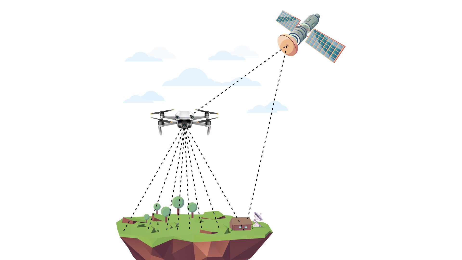
Mounted on aircraft or drones, LiDAR systems emit hundreds of thousands of laser pulses every second. While most are reflected by leaves and branches, enough penetrate the forest canopy to reach the ground below. Powerful software then filters away the vegetation, revealing the contours of the landscape with extraordinary precision. To archaeologists, it is almost like peeling away centuries of forest without disturbing a single tree.
The technology has not merely made exploration faster. It has fundamentally changed what researchers believe is possible. Landscapes once dismissed as empty wilderness are proving to have been densely inhabited. Civilisations thought to consist of scattered settlements are emerging as vast urban networks. This brilliant technology is rewriting long-held assumptions about population, agriculture and social organisation.
Ancient Maya World
Nowhere has that transformation been more dramatic than in the Maya lowlands of northern Guatemala.
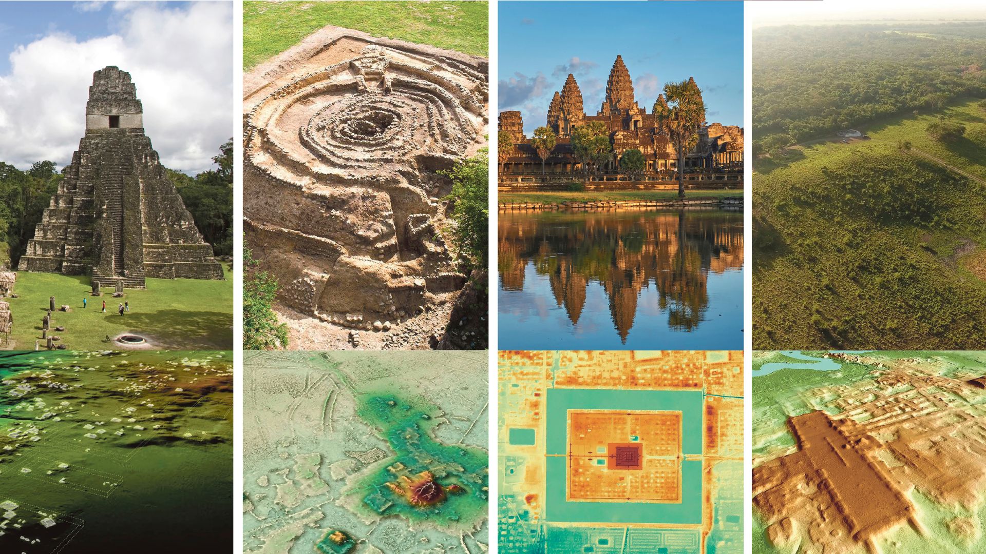
For decades, archaeologists knew that the region around Tikal contained some of the greatest monuments of the ancient Maya world. Towering temples rose above the jungle, while carved stone monuments bore the names and achievements of powerful rulers, offering glimpses into a once-flourishing civilisation. Yet the dense rainforest concealed everything beyond the ceremonial centres. Moving through the jungle on foot was painfully slow, and even decades of excavation could only reveal tiny fragments of the broader landscape.

LiDAR changed everything. In 2018, an international team working with the PACUNAM LiDAR Initiative surveyed more than 2,100 square kilometres of the Guatemalan rainforest. What emerged stunned even seasoned archaeologists. Beneath the trees lay more than 60,000 previously unknown structures, including homes, palaces, terraces, defensive walls, reservoirs and elevated stone roads connecting settlements across the landscape.
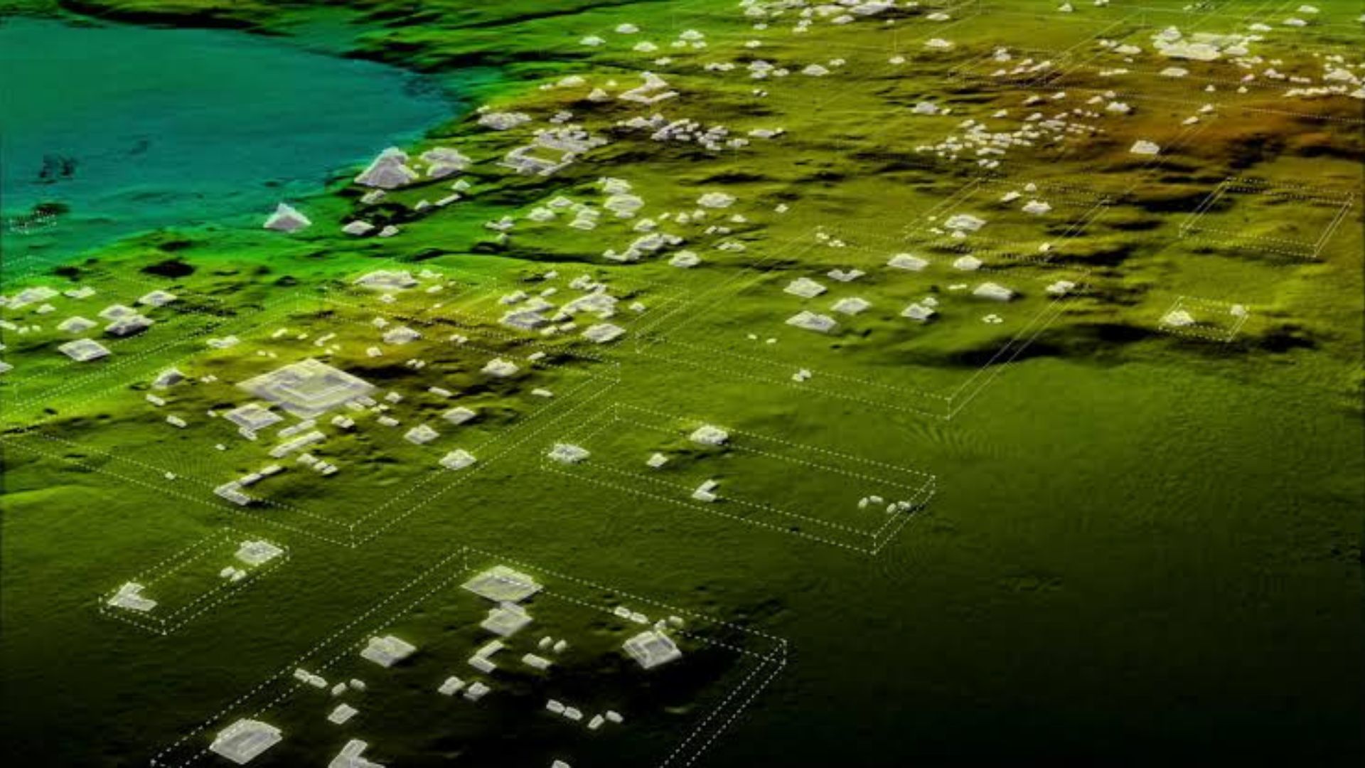
The discoveries suggested that the Maya had built one of the most extensive urban systems in the ancient world. Instead of isolated city-states separated by wilderness, researchers found evidence of an interconnected civilisation with sophisticated infrastructure and intensive agriculture capable of supporting millions of people.
When archaeologist Stephen Houston first examined the LiDAR maps, the scale of what they revealed was overwhelming. “I know it sounds hyperbolic, but when I saw the LiDAR imagery, it did bring tears to my eyes,” he told the BBC. After decades spent excavating Maya sites on foot, the laser survey revealed an ancient landscape on a scale few had imagined.
The implications extended far beyond Guatemala. For generations, history books portrayed the Maya as people who built magnificent ceremonial centres surrounded by relatively sparse rural populations. The laser maps revealed something far more complex: densely occupied landscapes shaped by generations of engineering, planning and environmental management.
Ancient highways, known as sacbeob, stretched across wetlands and forests, linking communities that may once have bustled with merchants, pilgrims and travellers. Massive reservoirs stored precious water through dry seasons. Hillsides had been carefully terraced to maximise food production. Defensive fortifications hinted at periods of conflict and political competition. The jungle, it turned out, had hidden not scattered ruins but an entire civilisation.
Khmer Empire




A similar revelation was taking place nearly 15,000 kilometres away in Cambodia. The temples of Angkor have long stood among the world’s greatest archaeological treasures. Visitors marvel at the soaring towers of Angkor Wat. Yet for all its grandeur, Angkor was only part of a much larger story.
For years, archaeologists suspected that an enormous city surrounded the famous temples, but the dense vegetation made it almost impossible to understand its full extent. LiDAR provided the missing map.
Flying over Cambodia’s forests, researchers uncovered forgotten neighbourhoods, hidden temples, canals, reservoirs and an intricate network of roads radiating from Angkor’s monumental core. What had appeared to be isolated architectural masterpieces were revealed as the heart of one of the largest pre-industrial cities ever constructed.
The scans also exposed the extraordinary sophistication of the Khmer Empire’s hydraulic engineering. Vast reservoirs, channels and embankments formed a complex system for collecting, storing and distributing water across the landscape. These works sustained a flourishing urban population for centuries, demonstrating an understanding of environmental management that continues to impress engineers today.
Equally striking was the scale. Many of Angkor’s wooden homes, markets and public buildings had long since disappeared, leaving behind only the stone temples that could withstand time. LiDAR uncovered the subtle traces they left on the ground, restoring the outline of a living city rather than a collection of isolated monuments.
The discoveries also reminded archaeologists of an important truth: what survives is not always representative of what once existed. Stone temples endure. Wooden houses decay. Forests reclaim abandoned streets. Without technologies capable of looking beneath the vegetation, entire chapters of human history can remain invisible for centuries.
Discoveries in the Amazon
That lesson is now reshaping another landscape long considered one of the world’s last great wildernesses: the Amazon rainforest.
The Amazon has long occupied a special place in the human imagination. It is often described as the world’s last great wilderness, a vast green expanse where nature reigns supreme and human footprints are few. For much of the twentieth century, archaeologists believed the rainforest’s poor soils and harsh environment made it impossible to sustain large, complex societies. Indigenous communities were thought to have lived in small, scattered villages, moving with the rhythms of the forest rather than reshaping it.
The lasers told a different story. As LiDAR surveys expanded across parts of Brazil, Bolivia and Ecuador, geometric patterns began appearing beneath the canopy. Perfect circles and squares emerged where no natural formations should exist. Broad roads stretched through the forest, linking settlements separated by kilometres of dense vegetation. Earthen platforms, defensive embankments, canals and ceremonial centres slowly came into view.
What initially looked like isolated discoveries soon formed a remarkable pattern. In Bolivia’s Llanos de Mojos, researchers mapped sprawling settlements belonging to the Casarabe culture. Some covered several square kilometres and featured monumental platforms, channels, reservoirs and carefully planned road systems. Rather than living in isolated villages, these communities occupied interconnected urban landscapes that flourished more than a thousand years ago.
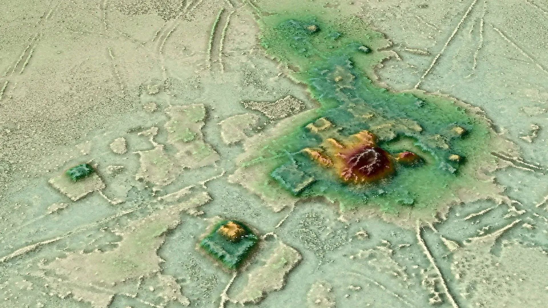
Farther north, in Ecuador’s Upano Valley, archaeologists uncovered an equally astonishing network of settlements linked by wide roads and organised into carefully planned neighbourhoods. Many researchers now believe these were among the largest ancient urban systems ever discovered in Amazonia, challenging decades of assumptions about how people adapted to one of the world’s most demanding environments.
Perhaps the greatest revelation is not simply that these cities existed, but that they were built in partnership with the forest rather than in opposition to it. Ancient Amazonians engineered fertile soils known today as terra preta, redirected waterways, cultivated orchards and managed forests over generations. The rainforest that European explorers encountered was not entirely untouched nature. In many places, it was a landscape shaped by centuries of human ingenuity.
These discoveries are forcing historians to reconsider one of archaeology’s oldest assumptions: that cities and civilisation emerged only where rivers, fertile plains or temperate climates offered obvious advantages. Increasingly, evidence suggests that human societies found remarkably diverse ways to flourish, adapting creatively to environments once thought inhospitable.
Aguada Fénix
In the Mexican state of Tabasco, archaeologists were studying what appeared to be a gently rising natural ridge when LiDAR revealed something altogether unexpected. The feature was not a hill at all but an enormous man-made platform.
Named Aguada Fénix, the structure stretches nearly 1.4 kilometres in length and rises up to 15 metres high in places, making it one of the largest monumental constructions ever built by the ancient Maya. Dating to roughly 1000-800 BC, it predates many of the civilisation’s famous pyramids and royal dynasties.
Its significance extends beyond its sheer size. Unlike later Maya cities dominated by powerful kings and elaborate palaces, Aguada Fénix appears to have been built before rigid social hierarchies emerged. Archaeologists believe thousands of people may have worked together voluntarily to create the immense ceremonial complex. That suggests that cooperation may have been the driving force behind some of humanity’s earliest monumental architecture.
The discovery serves as a reminder that archaeology often challenges not only what we know but how we think. For generations, historians assumed that large public works required powerful rulers directing vast labour forces. Aguada Fénix hints at another possibility: communities united by shared beliefs and collective purpose long before the rise of kingdoms and empires.
Yet for all its extraordinary capabilities, LiDAR do es not replace archaeology. It enhances it.
A laser scan can reveal the outline of a buried structure, but it cannot explain who built it, what language its inhabitants spoke or why they abandoned it. Those answers still come from painstaking excavation, radiocarbon dating, microscopic soil analysis, ancient pollen, pottery fragments and countless hours spent in laboratories and field camps.
In many ways, LiDAR has become archaeology’s most valuable guide rather than its replacement. Instead of wandering through dense forests hoping to stumble upon hidden ruins, researchers can now identify promising locations with remarkable accuracy before setting foot on the ground. Expeditions that once required years of exploration can be planned in weeks, allowing archaeologists to spend more time interpreting the past than searching for it.
The technology continues to evolve. Compact LiDAR systems mounted on drones are making surveys faster and more affordable. Artificial intelligence is beginning to analyse the enormous datasets produced by laser mapping, identifying subtle patterns that even experienced researchers might overlook. Combined with satellite imagery and ground-penetrating radar, these tools are ushering archaeology into an era where discoveries increasingly emerge from the intersection of history, engineering and computer science.
Yet despite these technological advances, the excitement of discovery remains remarkably human. There is still a moment when an archaeologist sees the unmistakable outline of an ancient road or the geometric footprint of a forgotten temple for the very first time. It is the same thrill that explorers experienced generations ago, only the path to that moment has changed.
The machete has given way to the laser. The compass has been joined by algorithms. But the wonder of uncovering a lost world remains exactly the same.