
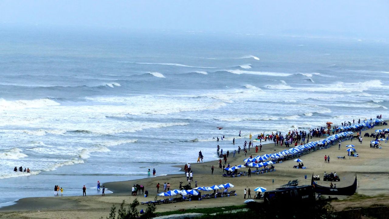

Cox’s Bazar Sea Beach, stretching nearly 120 kilometers, was once the world’s longest uninterrupted natural sandy beach. However, today, this coastline is not just vanishing because of rising seas or stronger storms in some simple, direct way. It is losing its own natural ability to bounce back, or recover after disruptions. The question is why.
For thousands of years, earthquakes, rivers, ocean currents, and cyclones have worked together to shape and sustain this beach. Sand and sediment has built this living landscape. The Ganges–Brahmaputra–Meghna (GBM) river system, together with local rivers and streams such as the Matamuhuri, Reju, Bakkhali, and Naf, dump billions of tons of sediment into the Bay of Bengal each year. Ocean currents then transport and deposit these sediments along the coast, helping the beach grow and gradually expand westward.
Since there are no large natural coral reefs or rock formations at Cox’s Bazar, waves reach the shore with their full energy. The combination of regular ocean waves, southwest monsoon waves, and cyclone-driven storm surges continuously shape this unique beach system.
During the southwest monsoon waves, arrive at the coast at an angle to the shore, driving sand movement from south to north. The movement of sand between rivers, estuaries, and wetlands and the beach also occurs on natural cycles tied to tidal cycles and major cyclones also deliver large amounts of sediment to reform the dune systems and naturally rebuild the coast. The beach system, made up of the shoreline, beachface, sand berm, and dunes changes seasonally, over the course of the year.
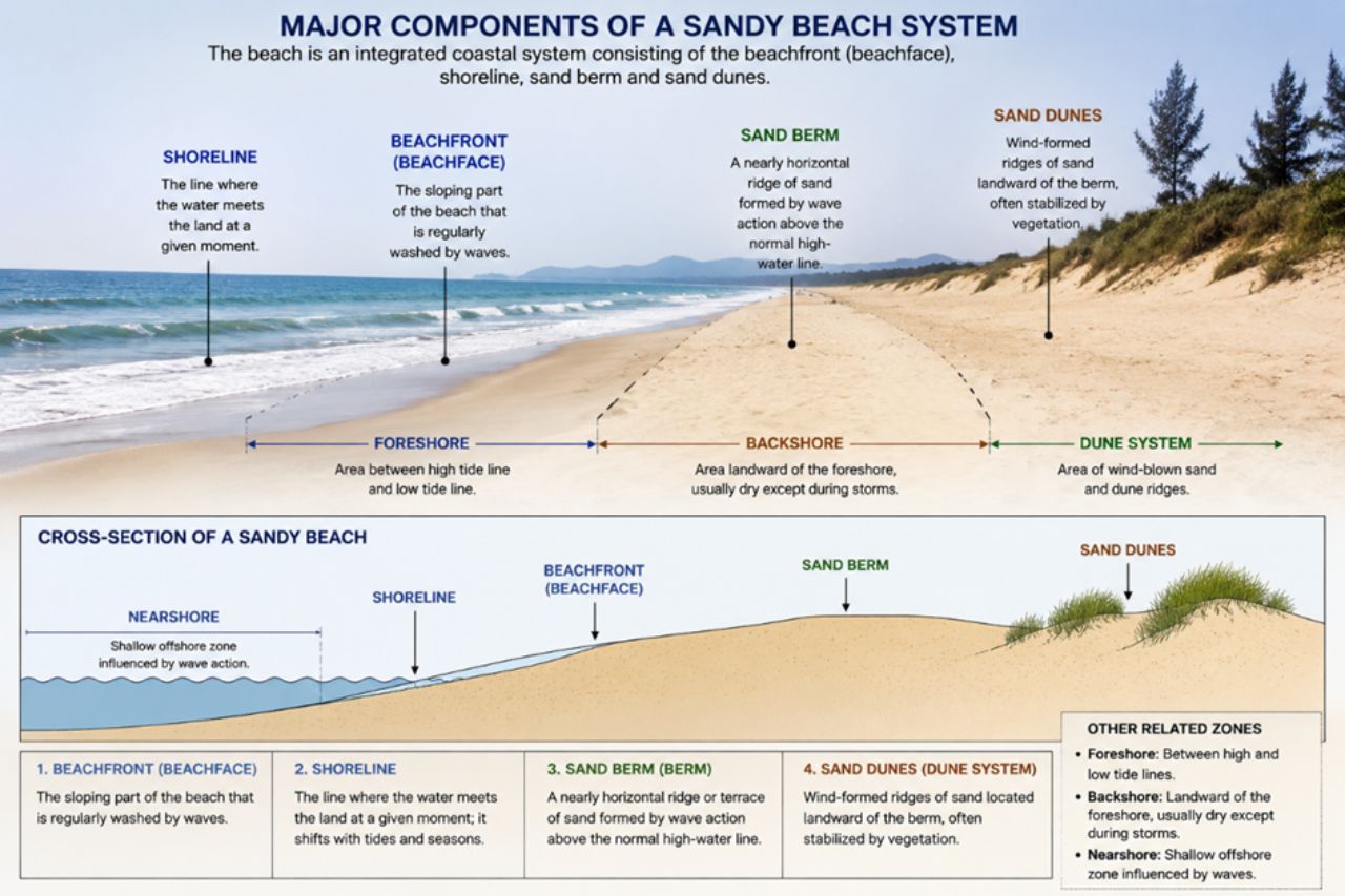
Wetlands behind the dunes store fine sediment, process minerals under low-oxygen conditions, and return nutrient-rich sand to the beach during cyclones, helping pioneer plants establish and maintain the beach’s stability.
Wind gives the dunes their final shape. During the dry season, sea breezes carry fine sand inland, where Sagorlota (Ipomoea pes-caprae) begins dune formation. Unhatched Olive Ridley turtle eggs enrich the sand, while burrowing red ghost crabs create ideal nesting conditions. As dunes mature, deep-rooted native plants—including Keya (Pandanus odorifer), Nishinda (Vitex negundo), and Nona Jhau (Tamarix dioica)—stabilize the sand, retain moisture, reduce erosion, and support countless small organisms. Together, they form the coast’s first line of defence, storing sand that naturally replenishes the beach after storms.


Replacing native vegetation with Australian pine (Casuarina equisetifolia) weakens the dune system. Its shallow fibrous roots suppress native plants, compact beach sand, reduce biodiversity, and accelerate erosion as storm waves easily scour sand around the roots and topple the trees.
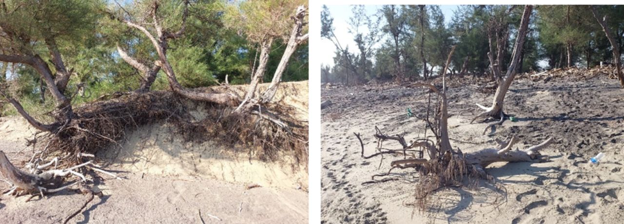
Although much of the original dune ecosystem has disappeared, remnants remain. Sagorlota (Ipomoea pes-caprae) and Viukata (Solanum virginianum) still survive in parts of Cox’s Bazar and Maheshkhali, while Nishinda (Vitex negundo) and Keya (Pandanus odorifer) continue to stabilize dunes on Sonadia, Maheshkhali, and St. Martin’s Island.
The beach, estuaries, wetlands, rivers and surrounding hills form a single interconnected Earth system. Keystone species— Olive Ridley turtles, red ghost crabs, horseshoe crabs, Irrawaddy dolphins, Asian elephants, and native forests help sustain sediment movement, biodiversity, freshwater recharge, and ecological balance.



Forests in Ukhiya, Teknaf, Ramu, Eidgaon, Chakaria, and the upper Matamuhuri–Bakkhali catchments supply the freshwater and sediment that rebuild Cox’s Bazar Beach. When forests are cleared, wetlands filled, rivers dammed, groundwater over-extracted, or keystone species decline, the beach loses its natural ability to recover after storms.
For more than 100 years, wrong state policies, planning and development interventions have dramatically altered the Cox’s Bazar coastal system. O’Malley (1908) and Allen’s early historical accounts noted that construction of embankments and similar structures had impacted on natural drainage and freshwater flow leading to water-logging and gradual transformation of productive loamy soils into saline clay. From the 1960s the development of salt farming, shrimp culture, sluice gates, rubber dams and coastal infrastructure have resulted in a further restriction on the flow of fresh water from hills to sea.
Salinity is quietly eating away at Cox’s Bazar’s natural defences. Maheshkhali, Matarbari, Kutubdia, Pekua, and parts of Teknaf now face severe saltwater intrusion, while Chakaria and Eidgaon are becoming increasingly saline. Many of these areas were once home to thriving coastal mangrove forests.
As salt spreads inland, it changes the chemistry of beach sand, dune vegetation weakens, wetlands lose their ability to nourish the beach and disrupts sediment transport. Meanwhile, commercial plantations, Australian pine (Casuarina equisetifolia), shrimp farms, salt fields, and inappropriately planned coastal development continue to fragment habitats, reduce groundwater recharge, and dismantle the natural barriers that once protected the coastline.
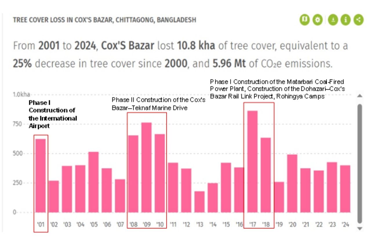
Over the past three decades, development policies have largely prioritized GDP-driven growth over local livelihoods. In 1991, “Hotel-Motel Zone” project displaced families from their ancestral villages, while in 1994 “Coastal and Wetland Biodiversity Management at Cox’s Bazar and Hakaluki Haor” project financed the Marine Drive despite warning that it would accelerate land-use change and development pressure along the coast.
The Coastal Zone Policy 2005, further promoted tourism infrastructure and private investment along the coast. Today, severe erosion at Laboni Point, Kolatoli, Himchari, and along the Marine Drive—including sections protected by seawalls—reveals the long-term ecological cost of these decisions. From an Earth-system perspective, the old Cox’s Bazar–Teknaf Marine Drive road (east of the new one) via Inani–Court Baza remains the more sustainable corridor because it largely avoids the dynamic beach–dune system while maintaining regional connectivity.
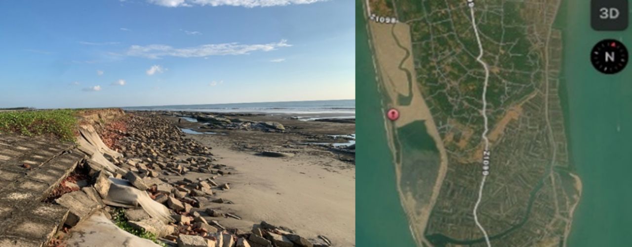
Perhaps most striking is the warning from Sabrang and Shah Porir Dwip. Located at the southern tip of Cox’s Bazar, they form part of a highly dynamic estuarine system shaped by the Naf River, tides, waves, and sediment transport. Between 1990 and 2025, the area suffered a net loss of nearly 13.7 km² of land due to construction of roads, embankments, hard coastal structures, and filling of wetland that disrupted the natural sediment transport system along the Teknaf coast, reducing the coastline’s natural capacity to recover from erosion.
Satellite imagery shows that Cyclone Komen (2015) and Cyclone Roanu (2016) redistributed sediment across the estuary and floodplains. From 2017 onward, large-scale sand filling buried tidal channels and wetlands, and roads were built between 2020 and 2023. During the 2025 high tides, section of “Sabrang Eco-Tourism Zone” road collapsed, exposing the buried wetlands. The sequence demonstrates that blocking natural estuaries, floodplains, and wetlands disrupts sediment transport, and ultimately accelerates erosion rather than preventing it.
The ecological degradation has turned into social and economic crisis. As forests, wetlands, fisheries, and farmland decline, families lose access to the natural resources that once supported farming, artisanal fishing, boat building, forest-product collection, and other traditional livelihoods.
Over the past several decades, government policies and large-scale development projects—including embankments, shrimp and salt expansion, inappropriate tourism, coastal roads, and the conversion of forests and wetlands—have transformed Cox’s Bazar from a self-reliant, nature-based economy into a market-dependent one. Although these developments created new economic opportunities, they also replaced diverse local livelihoods with more fragile sources of income.
The benefits rarely reach those who depend most on the coast. While shrimp farming and tourism generate substantial wealth, investors, and intermediaries capture most of the profits. Peasants and artisanal fishermen continue to produce much of the region’s wealth while coping with declining returns, insecure employment and growing environmental risks.
Proliferation of salinity, groundwater depletion, fisheries collapse, and environmental damage continues to impact household production. Thus, households are increasingly relying on purchased food, fresh water, fuel, inputs, seasonal work and loans. Rather than building resilience, our current development model has left families deep in debt and more vulnerable to volatile global markets and extreme environmental and economic shocks beyond their control.
We need to learn to build it in tandem with the Earth, not against it.
Khondker Neaz Rahman is an Urban and Regional Planner, while Sumaiyah Rahman is an Architect.